AY Honors/Navigation/Answer Key
Approval authority:
Category:
Skill Level:
Year of Introduction:
![]()
Contents
|
This Honor is a component of the Aquatic Master Award. |
1. Have the Weather Honor
For tips and instruction see Weather.
- Aboard
- on board, or being present on a boat.
- Aft of after
- toward or near the rear of a boat.
- Amidships
- halfway between the front and rear of a boat.
- Astern
- behind the boat or backwards.
- Bay
- a body of water partially enclosed by land but with a wide mouth, affording access to the sea.
- Beacon
- a signaling or guiding device, such as a lighthouse, located on a coast.
- Binnacle
- protective box for a compass.
- Bollards
- short, heavy posts on a pier for securing boats.
- Bow
- the front section of a ship or boat.
- Buoy
- a float moored in water to mark a location, warn of danger, or indicate a navigational channel.
- Channel
- the deeper part of a river or harbor, especially a deep navigable passage.
- Cuddy
- small space under the foredeck for storage.
- Fathom
- a unit of length equal to 6 feet (1.83 meters), used principally in the measurement and specification of marine depths.
- Draught
- the depth of a loaded vessel in the water, taken from the level of the waterline to the lowest point of the hull.
- Galley
- marine name for kitchen.
- Harbor
- a sheltered part of a body of water deep enough to provide anchorage for ships.
- Hatch
- an opening through the deck through an area below.
- Heading
- the course or direction in which a ship or aircraft is moving.
- Heave
- marine name for throw.
- Helmsman
- pilot of the boat, the person who steers.
- Hull
- the main body of the boat.
- Keel
- the backbone of the boat that extends from bow to stern.
- Knot
- a unit of speed, one nautical mile per hour, approximately 1.85 kilometers (1.15 statute miles) per hour.
- Latitude
- the distance north or south of the earth's equator, measured in degrees along a meridian, as on a map or globe.
- Leeward
- the direction the wind is blowing.
- Longitude
- distance on the earth's surface, measured east or west from the prime meridian at Greenwich, England, to the meridian passing through a position, expressed in degrees (or hours), minutes, and seconds.
- Port
- left side of a boat when looking toward the bow.
- Sounding
- A measured depth of water.
- Starboard
- the right side of a boat when looking toward the bow.
- Stern
- back end of the boat.
- Swab
- marine name for a mop.
- Underway
- when a boat is moving through the water.
- Waterway
- A navigable body of water, such as a river, channel, or canal.
- Waypoint
- a point between major points on a route, as along a track.
An aid to navigation is any device external to a craft that is designed to assist in determining the location of the craft, a safe course for the craft, or to warn of dangers. Most aids to navigation are established and maintained by the government. In the U.S., this is done by the Coast Guards.
- a. Lighthouse
- are located along the seacoast and at important harbor entrances. They operate automatically without a full-time lighthouse keeper.
- b. Beacon
- miniature, unmanned, lighthouses that are placed along banks and ledges to mark isolated dangers. Horns and mechanical bells are sometimes used in beacons during times when visibility is low.
- c. Buoys
- floating navigational aids that are divided into 3 categories- unlighted, sound, and lighted.
- d. Radio beacons
- by use of radio signals, this system is designed to meet at least 3 objectives: to give a nearly continuous 2 position line capability to a distance offshore of at least 50 miles: to give working ranges up to 160 miles at certain key locations for approaching from far offshore and to provide continuous, low-powered guidance for inshore navigation.
4. Name six types of buoys. What do they mean and how are they used? Give the colors of the six you named. How are buoys numbered? How do they mark channels?
Buoys used to mark the edges of channels:
- a. Nun buoys
- painted red with even numbers.
- b. Can buoys
- painted black with odd numbers.
- c. Spar buoys
- are painted red with even numbers and black with odd numbers. When entering a harbor, keep red buoys to starboard, and black buoys to port.
Buoys used to mark obstructions, anchorage, fishing nets, and fairways:
- a. Mid-channel buoys
- have a white light and have white and black vertical stripes. They show the direction to the harbor.
- b. Fairway buoys
- may be of any shape. They are painted black and white vertical stripes. These buoys mark the center of a channel or fairway and should be passed close aboard on either hand.
- c. Anchorage buoys
- are always white and mark where an anchorage may be made.
The compass is used along with a geometry compass, dividers, parallel rules, a straightedge, and a protractor to find the boat’s position on charts. When the sky is overcast and there is no land in sight, it is very easy to get disoriented. The compass will keep you on course and help you find your way back to port. Compasses are meant to be mounted on bulkheads, atop consoles, gimbals, or brackets. Some are flushed and mounted. Flush mounts are better because they transmit less vibration than a bracket-mount compass. The compass should have a guard to protect it from damage and a hood to eliminate sun glare.
6. Name four of the most useful knots in seamanship. Know how to tie them and give their principal uses.
Adventist Youth Honors Answer Book/Knot/Two half hitches
Adventist Youth Honors Answer Book/Knot/Bowline
Adventist Youth Honors Answer Book/Knot/Figure 8
Adventist Youth Honors Answer Book/Knot/Mooring Hitch
Adventist Youth Honors Answer Book/Knot/Sheetbend
7. Familiarize yourself with reading and interpreting a "chart." Why is a chart so invaluable in unknown waters? Give some of the things a chart shows. Give the symbols used on a chart, or two of the most used buoys.
- Stay alert to nearby vessels, hazards and changing weather conditions. Refrain from substances or practices that could impair judgment or alertness (e.g. alcohol, lack of sleep).
- Travel at safe and appropriate speeds.
- Follow the "rules of the road."
9. What does it mean to be properly equipped? Illustrate.
A ship properly equipped will be outfitted with every mechanical aid to needed for navigation.
10. What is meant by "rules of the road" and by "proper water etiquette?"
For the purposes of the sailing honor we will focus in the rules of the road that apply to small sailing boats.
It is important to note here that you are responsible for learning the rules and regulations that apply to whichever boat you are operating in the country and state or province where you are operating the boat.
There are five basic rules of the road for small sailing boats to decide who has the "Right-of-Way" so that each boat's skipper (driver) will know what to do to avoid a collision.
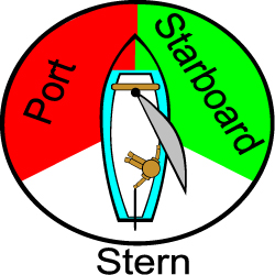
When sailing the words "left" and "right" in reference are replaced with "port" and "starboard". It is important to remember which is which since the rules of the road for sailing rely on using these words to assign right-of-way.
You might be able to remember this by noticing that the letter "R" appears twice in the word "starboard", and only once in "port". Then since "right" begins with "R", you will know that the right hand side of the boat when facing forward is the starboard side.
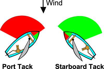
The next item to remember is the word "tack" and how it is used to describe which side of the boat the wind is blowing from. As seen in the illustration below, if the wind is coming from the right hand side of the boat, and the sail is on the left side, the boat is on a starboard tack. When the wind and sail are reveresed, the boat is on a port tack.
Rule Number 1:
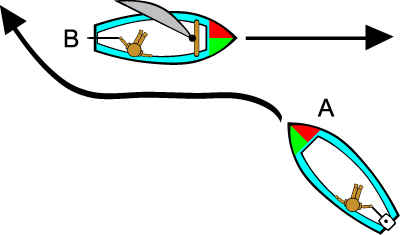
When two sailboats are approaching each other and are on different tacks, the boat on the starboard tack has the right-of-way over the boat which is in the port tack. An easy way to remember this is to think about power boat lights. At the front the boat has red on the port (left side) and green to the starboard (right). If you are approaching a boat and can "see" the red light, then the other boat has the right of way. (small sail boats rarely have the actual lights, but you can imagine them)
In the illustration below, boat "A" on the port tack, must turn to avoid boat "B" on the starboard tack.
Rule Number 2:
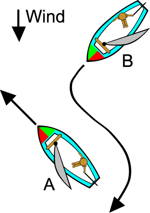
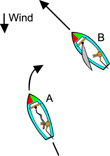
When two sailboats are approaching each other and are on the same tack, the leeward boat has the right-of-way over the windward boat. Another way to say this is to say that the boat closer to the wind source must keep clear. The boat further from the wind source has the right-of-way.
In the illustration below, boat "B" is the windward boat and must turn to avoid boat "A" which is leeward.
Rule Number 3
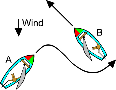
A sailboat that is staying on a tack has the right-of-way over a sailboat that is tacking or gybing. A simpler way to say this is to say "make sure you have room to complete a tack or a gybe without interfering with any other boats before doing so". Make sure that you can see clearly in all directions to ensure you have room.
In the illustration below, boat "A" must ensure that it leaves plenty of room to avoid boat "B", who has the right-of-way, since boat "B" is continuing on its tack. However, in the event that boat "A" was unable to tack due to the proximity of "B", remember that "A" is the leeward boat so therefore could tell boat "B" to give room to tack, but would lose this right of way as soon as they actually began to tack.
Rule Number 4
Any sailboat that is overtaking a slower boat from behind must steer clear of the slower boat and give right-of-way. The slower boat should hold its course and allow the faster boat to pass.
In the illustration below, boat "A" is a faster boat, and must steer around the slower boat "B", who should remain on the same course.
Rule Number 5
Most of the time sailboats have the right-of-way over power boats. Since most powerboats are more easily maneuverable than sailboats, they must steer clear. This is not always the case however. Larger power boats are sometimes steering in the deep channel of the area, and cannot leave the channel. In this case the sailboat does not have right-of-way, and must avoid impeding the progress of the larger vessel. Many larger power boats cannot simply stop quickly or easily turn to avoid a small sailboat, so it is in the sailor's best interest to steer well clear of these larger boats.
In the illustration below, the powerboat "A" must turn to avoid the sailboat "B", who has the right-of-way.
